|
|
Personal Weather Station Measurements
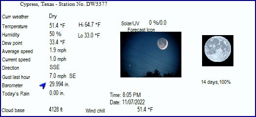
DW3377 Cypress, Texas
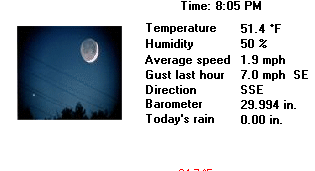
LAST READING AT TIME: 8:05 PM, 11/7/2022
TIME OF NEXT UPDATE: 8:10 pm |

|
Current
Conditions |
Dry Night Feels Like 51.4°F |
 |
| Temperature & Humidity |
| |
|
|
| 51.4°F |
33.0°F |
64.7°F |
|
50 % |
26 |
69 |
| 7:01 AM |
1:44 PM |
11:59 AM |
6:43 AM |
| 48.6 |
- |
- |
|
33.4°F |
23.9 °F |
33.5 °F |
| 51.4 |
Heat Index |
51.5°F |
7:52 PM |
7:19 AM |
| Humidex |
47.9°F |
| Wind Chill |
51.4°F |
| 48.6 |
48.6 |
50.6 |
| 8:05 PM |
6:45 PM |
| 49.0 F |
49.0 F |
50.8 F |
| Wind & Barometer |
| |
|
|
1.0 mph South |
15.0 mph SE at 12:31 PM |
|
29.994 in. |
29.932 in. |
30.105 in. |
| 12:20 AM |
8:32 AM |
| 1.9 mph SSE |
|
Steady +0.011in./hr |
| |
Rising +0.034 in. |
| Rain |
| |
| 0.00 in. |
|
9/21/2021 |
| 0.00 in. |
|
0.00 in. |
| 0.000 in/hr |
|
2.09 in. |
| 0.000 in/hr at 00:00 AM |
|
25.42 in. |
| Solar Radiation & Ultraviolent Index |
| |
|
|
| Dry |
|
720 minutes |
| 0.10 inches |
|
01:51 hours |
| |
|
UV Solar Scale |
 |
| 49.0 F |
49.0 F |
50.8 F |
|
| 0 W/M2 |
0 W/M2 |
544 W/M2 |
|
0.0 |
0.0 |
3.6 |
| 12:00 AM |
11:32 AM |
12:00 AM |
11:31 AM |
| Indoor Temperature & Humidity |
| |
|
|
| 72.6°F |
67.2 |
72.6 |
|
33% |
33 |
37 |
| 9:51 AM |
7:05 PM |
8:04 PM |
2:28 AM |
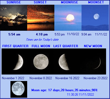
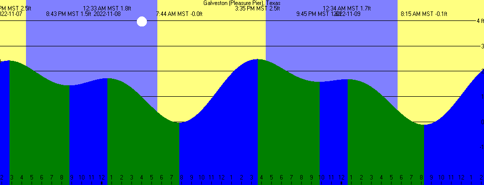
| Sun & Moon & Tides: Houston & Galveston, Texas |
 |
 |
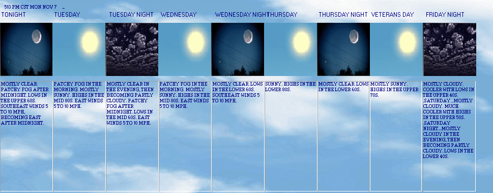
| 5 Day NOAA Southeast Texas Forecast |
513 PM CST MON NOV 7
|
SOUTHEEAST TEXAS INCLUDING THE CITIES OF...HOUSTON...HUMBLE...KATY...PASADENA...
|
| Current Advisories: |
NO CURRENT ADVISORIES |
 |
 |
 |
 |
 |
 |
 |
 |
| Tonight Mostly clear. patchy fog after midnight. lows in the upper 60s. southeast winds 5 to 10 mph, becoming east after midnight. |
Tuesday Patchy fog in the morning. mostly sunny. highs in the mid 80s. east winds 5 to 10 mph. |
Tuesday night Mostly clear in the evening, then becoming partly cloudy. patchy fog after midnight. lows in the mid 60s. east winds 5 to 10 mph. |
Wednesday Patchy fog in the morning. mostly sunny. highs in the mid 80s. east winds 5 to 10 mph. |
Wednesday night Mostly clear. lows in the lower 60s. southeast winds 5 to 10 mph. |
Thursday Sunny. highs in the lower 80s. |
Thursday night Mostly clear. lows in the lower 60s. |
Veterans day Mostly sunny. highs in the upper 70s. |
| Detailed Advisory Info.: |
NMZ218
There are no active watches, warnings or advisories |
National Weather Service Proposed Radar, Southeast Texas
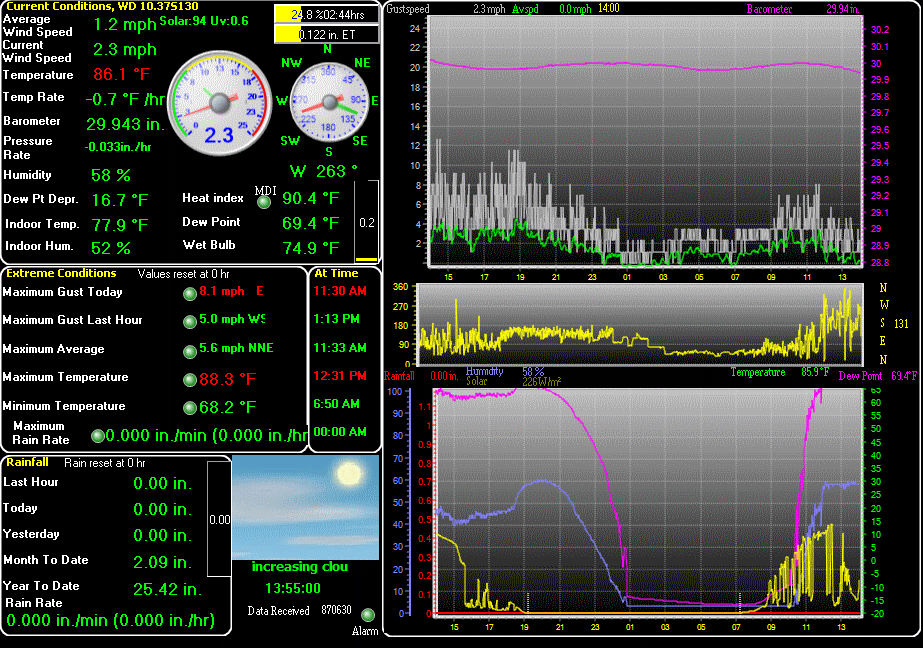
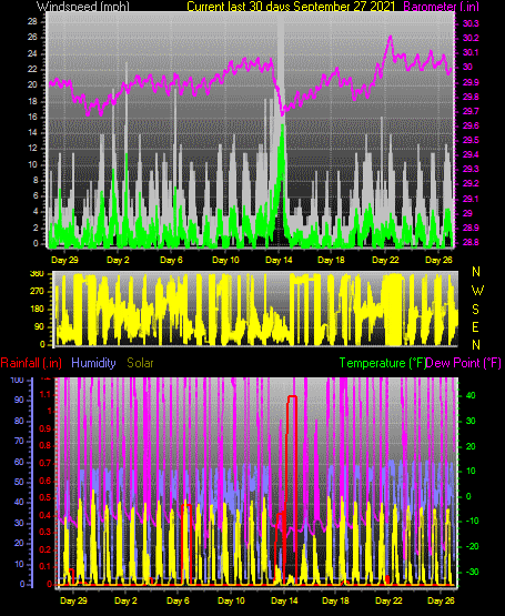
| Graphical Data from Weather Station DW3377, Cypress, Texas |
 |
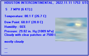
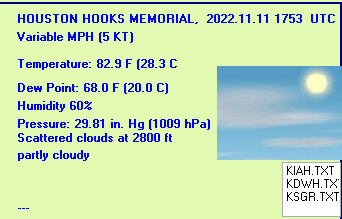
| Current Weather at Local Airports |
| Houston Intercontinental Airport (IAH), Houston, Texas |
Hook's Airport, Tomball/Klein, Texas |
 |
 |
This Weather Page was created using Weather Display v10.37S software
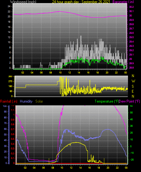
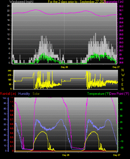
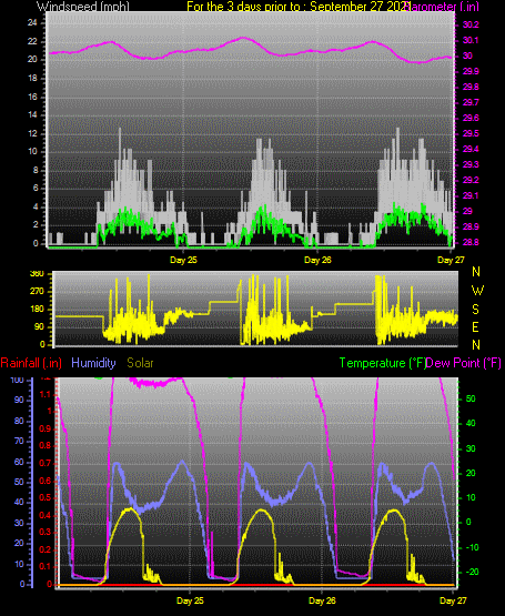
Summary
Summary 2, Local Weather
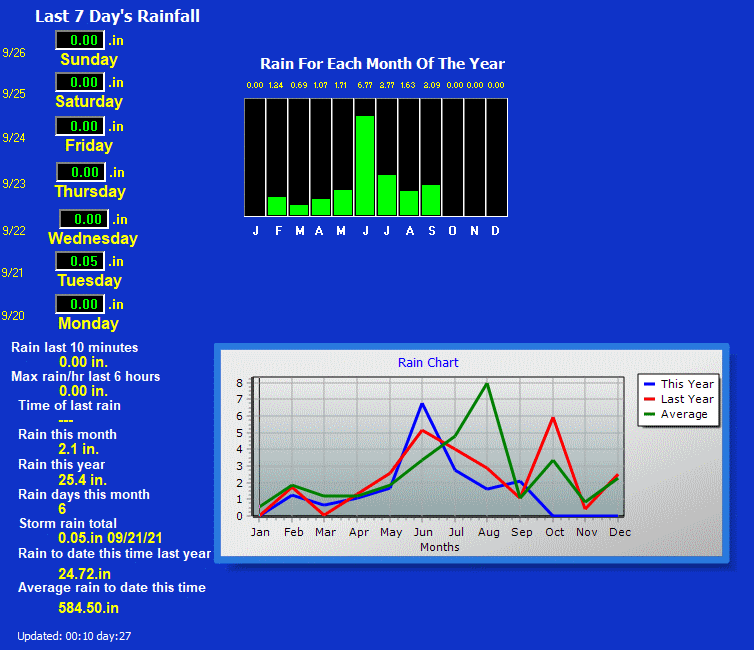
Rain Detail
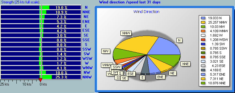
Wind Direction and Speed, Last 31 Days
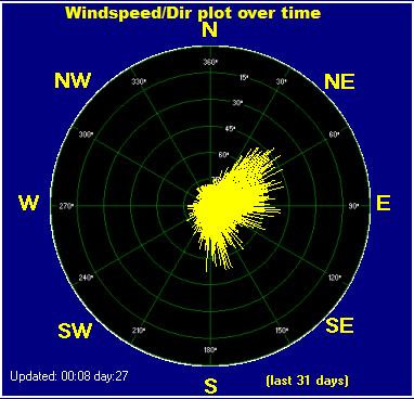
Wind Direction vs. Speed Plot, Month-to-Date
UV and Solar Radiation Details, Today
Tide Graph
Local Tide Predictions
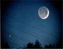
Gizmo
Forecast Icon, from Weather Station
Forecast Icon, Metar
Forecast Icon
5 Day Forecast
Graph, Yesterday
Graph, Last 48 Hours
Graph, Last 72 Hours
Graph, Month-to-Date
Averages\Extremes for the month
Texas APRSWXNET/CWOP Station Information Page
This page was last modified on
Monday, 07-Nov-2022 21:05:40 CST
|

